PHYSICAL DIVISIONS OF RAJASTHAN
PHYSICAL DIVISIONS OF RAJASTHAN
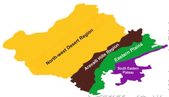
Rajasthan is geographically diverse, and its topography is divided into four distinct physical divisions:
- North-Western Desert Region (Thar Desert)
- Aravalli Hills Region
- Eastern Plain
- Hadoti Plateau (South Eastern Plateau)
General Information of Physical Divisions
The table below provides detailed data regarding each physical division:
| Division | Area | Population | Districts | Soil Type | Climate |
|---|---|---|---|---|---|
| Desert Region | 61.11% | 40% | 12 | Sandy Soil | Arid and Semi-Arid |
| Aravalli Hills | 9% | 10% | 13 | Mountain / Forest Soil | Sub-Humid |
| Eastern Plain | 23% | 39% | 10 | Alluvial Soil | Humid |
| Hadoti Plateau | 6.89% | 11% | 7 | Black / Regur Soil | Very Humid |
DETAILED OVERVIEW OF THE PHYSICAL DIVISIONS
- North-Western Desert Region (Thar Desert)
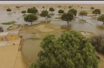
The North-Western Desert region is primarily dominated by the Thar Desert, one of the largest deserts in the world. It covers about 61.11% of Rajasthan’s total land area and is home to 40% of the population. The soil in this region is typically sandy, and the climate is predominantly arid and semi-arid, making it a harsh environment for vegetation and agriculture.
- Formation and Geological Background: The formation of the Thar Desert is attributed to the Tertiary or Pleistocene period, reflecting its ancient origins.
- Physical Dimensions of the Thar Desert:
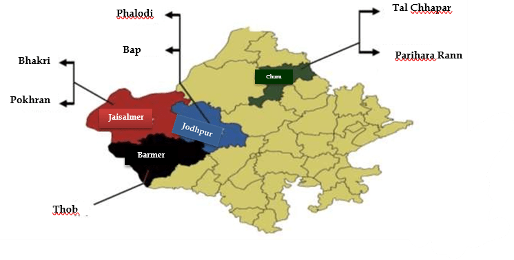
The above diagram depicts the extension of the Thar Desert across Rajasthan and adjoining regions, showcasing its vast geographical reach and scale.
The desert stretches across 12 districts in Rajasthan, which include some of the driest and most sparsely populated areas in the state.
Extension of the Thar Desert: The desert expands beyond Rajasthan’s boundaries, spreading into neighboring states and even into parts of Pakistan, making it a transnational geographical feature.
- Aravalli Hills Region
The Aravalli Hills are a prominent range that spans 9% of Rajasthan’s area and houses 10% of the population. The region is characterized by mountain and forest soils, supporting a variety of vegetation. The climate is generally sub-humid, and the region includes 13 districts.
The Aravalli Range is one of the oldest fold mountain systems in the world, with peaks averaging around 700 meters. Despite its age, the Aravalli range plays a crucial role in influencing the climate and water systems of Rajasthan, acting as a natural barrier to the desert’s expansion.
III. Eastern Plain
The Eastern Plain region covers about 23% of the state’s total area and supports 39% of Rajasthan’s population, making it the most populous physical division. The soil here is primarily alluvial, conducive to agriculture, and the climate is humid, with a moderate to high annual rainfall.
The Eastern Plain is known for its agricultural productivity, and its proximity to major rivers such as the Chambal and Banas makes it one of the more fertile areas in Rajasthan. This region includes 10 districts.
- Hadoti Plateau (South-Eastern Plateau)
The Hadoti Plateau, also referred to as the South-Eastern Plateau, covers about 6.89% of Rajasthan’s land area and is inhabited by 11% of the population. The plateau’s soil is predominantly black or regur soil, rich in nutrients and excellent for cultivating crops like cotton. The climate is very humid, with ample rainfall during the monsoon season.
The Hadoti region includes 7 districts and is known for its diverse landscape, which includes plateaus, ravines, and fertile valleys.
Key Facts Recap:
|
THAR DESERT: DETAILED STUDY AND DIVISION
Slope of the Desert
- The slope of the Thar Desert runs from North-East to South-West. This topographical feature significantly affects the distribution of rainfall and the formation of different desert regions.
Study of the Desert
From a geographical and climatic study perspective, the Thar Desert is divided into two distinct regions based on the amount of rainfall:
- Arid or Rathi Region (0–25 cm rainfall)
- Semi-Arid or Bangar Region (25–50 cm rainfall)
The demarcation of these regions is based on the 25 cm isohyet (a line on a map connecting points with equal rainfall). This isohyet serves as the division between the arid and semi-arid parts of the Thar Desert.
- Arid or Rathi Region
This region receives less than 25 cm of annual rainfall and is termed the Rathi Region. It is the most arid part of the desert, where the extreme lack of water results in minimal vegetation and harsher living conditions. The arid desert itself can be further divided into two sub-regions based on the presence of sand dunes:
- Without Sand Dunes Area: This part constitutes 41.5% of the arid desert. The land is more flat or rocky, and large sand dunes are absent.
- With Sand Dunes Area: This area covers 58.5% of the arid desert and is dominated by expansive sand dunes that characterize the typical desert landscape.
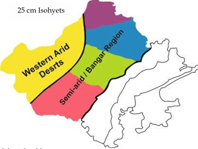
This diagram shows the division of the Thar Desert into the Arid (Rathi) Region and the Semi-Arid (Bangar) Region, with the 25 cm isohyet line separating the two. The Western Arid Deserts dominate the landscape.
- Semi-Arid or Bangar Region
The Semi-Arid Region, also known as the Bangar Region, receives slightly more rainfall, typically ranging from 25 to 50 cm annually. Though still a dry area, the semi-arid region supports a more significant amount of vegetation and agriculture than the arid region. The natural vegetation here is sparse, and human habitation is more frequent, relying on dry farming techniques.
25 cm Isohyet Line
The 25 cm isohyet line divides the Thar Desert into its arid and semi-arid sections. This line is a key meteorological marker that helps understand the distribution of rainfall and the varying ecological and geographical conditions within the desert.
The Thar Desert, one of the largest deserts in the world, showcases a variety of geographical features, influenced significantly by rainfall distribution. The division of the desert into the Arid Rathi Region and the Semi-Arid Bangar Region, based on the 25 cm isohyet, reflects the climatic extremes of Rajasthan. Furthermore, within the arid region, the presence of sand dunes creates a unique desert landscape that dominates over 58% of the area.
The importance of understanding these divisions lies in the distinct challenges they present, from agriculture and human habitation to biodiversity and ecological balance. The semi-arid regions, while still dry, offer more opportunities for agriculture and settlements compared to the harsh arid zones dominated by sand dunes.
AREAS WITHOUT AND WITH SAND DUNES IN THE THAR DESERT
(a) Without Sand Dunes Area:
- In this region, sand dunes are not found. Instead, the area is characterized by rocky terrain, often referred to as the Rocky Desert or Hamada.
- The Hamada region is a type of desert landscape that lacks sand dunes and is composed primarily of rocky plateaus. These areas are often found where wind erosion has removed finer sediments, leaving a rocky surface behind.
- Extension: The rocky desert extends across parts of Jaisalmer (notably in areas like Pokaran, Lodarava, Ramgarh), Barmer, Badmer, and Jodhpur.
These areas are vital in the study of desert landscapes, as they are formed due to different wind and erosion patterns compared to sand dune regions.
(b) With Sand Dunes Area:
- When wind deposits fine particles of soil and sand over time, the resulting formations are sand dunes.
- The maximum concentration of sand dunes in Rajasthan is found in the Jaisalmer region.
- Notably, Jodhpur has a diverse variety of sand dunes, making it one of the key regions for studying these geological formations.
Types of Sand Dunes
Sand dunes are dynamic landforms created by the movement of sand, primarily influenced by wind patterns. There are various types of sand dunes, each shaped by wind direction and strength. The two main types mentioned are Barkhan and Transverse Sand Dunes.
- Barkhan (Barchan Dunes)
- Barkhan dunes are crescent-shaped dunes that form when winds deposit sand in a curved formation. They are commonly found in areas with unidirectional winds.
- The windward side (from where the wind blows) has a convex slope, while the leeward side (where the wind moves away) forms a concave slope.
- The width of the barkhan ranges between 100 to 200 meters, and the height is approximately 10-20 meters.
- These sand dunes are highly mobile due to their formation in regions with consistent wind movement. As a result, they play a significant role in the process of desertification—the conversion of fertile land into desert—because of their dynamic movement.
- Location: Barkhan dunes are primarily found in the Shekhawati region, with the maximum concentration being in Churu.
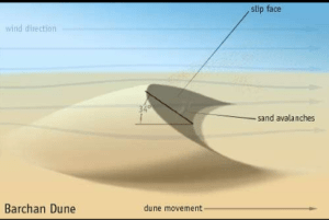
The diagram above illustrates the structure of a Barkhan dune. It shows the windward and leeward sides of the dune and how the movement of sand is shaped by the prevailing wind direction.
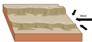
- Transverse Sand Dunes
- Transverse dunes form when the wind blows at a right angle to the sand deposition. These dunes appear as elongated ridges that run perpendicular to the wind direction.
- Transverse dunes are common in areas with strong, consistent winds that blow across vast sandy areas, causing the sand to accumulate in linear formations.
- These dunes are usually larger and more stable than Barkhan dunes, and they cover larger areas, forming continuous sand ridges.
- These sand dunes are mostly found in Barmer, Jodhpur.
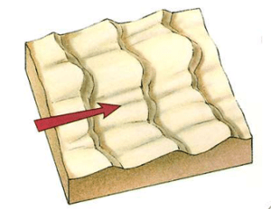
The images describe Transverse Sand Dunes, which are a particular type of sand dune formation.
- Longitudinal/Linear Sand Dunes
- Longitudinal dunes, also known as linear sand dunes, form when the sand is deposited parallel to the direction of the prevailing winds. These dunes develop in areas where wind directions are more consistent, causing the dunes to elongate and form parallel ridges.
- These dunes typically occur in regions where there is a limited amount of sand available but consistent wind flow.
- Longitudinal dunes can stretch over great distances, often forming long, narrow ridges that can extend for kilometers.
- Location: The Jaisalmer region in Rajasthan is home to several examples of longitudinal dunes, with their long ridges dominating parts of the landscape.
The above diagram demonstrates how the wind’s movement along a consistent direction causes sand to accumulate in linear, parallel dunes.
- Star-Shaped Sand Dunes
- Star-shaped dunes are formed when winds blow from multiple directions, creating a multifaceted structure that resembles a star. These dunes are relatively rare compared to other types and are often found in areas where wind patterns are complex or variable.
- The multiple arms of the star-shaped dunes point in different directions, reflecting the various wind directions that contributed to their formation.
- These dunes can be quite large and stable, as the competing winds prevent them from migrating significantly in any one direction.
- Location: Star-shaped dunes are commonly found in the Jaisalmer region, known for its diverse types of sand dunes. The complex wind systems in this area contribute to the formation of these unique structures.

In the images above, the star-shaped dunes display their multiple arms extending outward, formed by winds blowing from various directions.
- Formation: Star dunes are formed when the wind direction changes frequently in a desert environment. As a result of this variability in wind direction, the sand is pushed in multiple directions, causing the formation of a dune with several “arms” or ridges radiating outward from a central peak. Star dunes typically have three or more arms, resembling the shape of a star.
- Location: In Rajasthan, star-type sand dunes are mostly found in the regions of Jaisalmer, Suratgarh, and Sri Ganganagar. These areas have the necessary conditions for frequent changes in wind direction, allowing for the formation of these complex dune structures.
- Parabolic Sand Dunes
- Parabolic sand dunes are characterized by their U-shape, with the open end of the U facing upwind. These dunes are the reverse of Barkhan dunes, as their arms point in the opposite direction. They form when vegetation partially stabilizes parts of the dune, preventing sand movement in those areas.
- The middle section of the dune (the slip face) moves forward with the wind, while the arms (or horns) remain fixed due to the presence of vegetation.
- Location: These dunes are most commonly found in various parts of Rajasthan, and they often occur in more vegetated desert areas. The stabilization provided by plants helps maintain their shape.
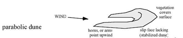
The diagram illustrates how parabolic dunes are formed by wind. Vegetation stabilizes the arms while the slip face moves forward, leading to the characteristic U-shape.
- Seif Sand Dunes
- Seif dunes are formed when there is a change in wind direction during the formation of a Barkhan dune. One of the arms of the Barkhan dune extends further due to this change, creating a long, narrow ridge. The word “Seif” means “sword” in Arabic, referring to the dune’s sharp, elongated shape.
- Seif dunes are similar to longitudinal dunes but result specifically from changes in wind direction affecting an existing Barkhan dune. Over time, Seif dunes can grow to be several kilometers long.
- Location: Seif dunes can be found in regions where wind patterns fluctuate, contributing to the extension of the Barkhan arm.
The diagram explains how Seif dunes develop from the extension of a Barkhan dune arm when wind direction changes.
- Scrub Coppice
- Scrub coppice refers to small, hardy bushes and shrubs that grow in desert areas. These plants are well-adapted to the harsh, arid conditions of the desert and play an important role in stabilizing the sand.
- These plants are often found growing in small clusters and help reduce wind erosion by trapping sand around their roots, thereby preventing the formation of large dunes.
- Vegetation in the Thar Desert, like scrub coppice, is sparse and highly drought-resistant. These plants can survive with minimal water and contribute to the delicate ecological balance in desert areas.
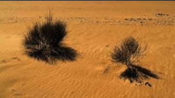
The image above shows scrub coppice in the desert, demonstrating how these small plants can grow in arid conditions and help stabilize sand dunes by anchoring the soil.
Semi-Arid Desert (Bangar Region)
The Semi-Arid Desert, also referred to as the Bangar Region, lies between the Arid Desert and the Aravalli Range. This physical division is defined by areas that receive 25 to 50 cm of annual rainfall, marked by the 25 cm and 50 cm isohyet lines on the map. Due to its relatively higher rainfall than the arid region, the semi-arid area supports a greater variety of vegetation and human activity, including some forms of agriculture.
.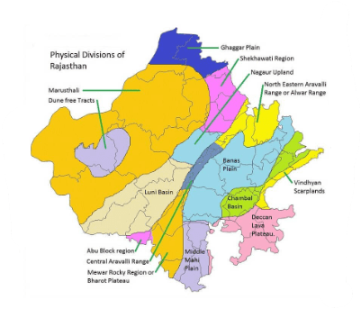
The map you provided outlines the Physical Divisions of Rajasthan and highlights the various geographical regions across the state.
Sub-Divisions of the Semi-Arid Desert
The Semi-Arid Desert is divided into four parts, each with distinct geographical and hydrological features:
- Luni Basin
- Nagauri Upland
- Shekhawati Inland Drainage Area
- Ghaggar Basin
(a) Luni Basin
- The Luni Basin, also known as the Godwad Basin, extends across several districts, including Jalore, Pali, Barmer, Sirohi, and Jodhpur. The Luni River, which flows through this basin, is a significant water source in the otherwise dry landscape. The basin is named after the Luni River, which is a saline, seasonally flowing river.
- Halophytes (plants adapted to saline conditions) thrive in this basin, particularly in Barmer, where the soil contains high salt content.
- Notable geographical landmarks within the Luni Basin:
- The Rann of Nehar in Jalore.
- The Kala Bhura Dungar located in Pali, situated to the east of the basin, is another significant feature.
(b) Nagauri Upland
- The Nagauri Upland is renowned for its brine water lakes, which are the highest found in the region of Nagaur. These lakes provide important water sources in the desert landscape.
- The region also suffers from high fluoride levels in groundwater, causing widespread cases of fluorosis. This region is referred to as the Hump Belt or Banka Belt, situated between Nagaur and Ajmer. The prevalence of fluoride contamination poses a severe public health concern.
(c) Shekhawati Inland Drainage Area
The Shekhawati Inland Drainage Area is another significant part of the semi-arid region. The term “inland drainage” refers to the fact that rivers and streams in this area do not flow into the sea but instead terminate in lakes, marshes, or other land-locked bodies of water.
- The Torawati region refers to the drainage or catchment area of Kantal, a critical area for managing water resources.
- A Johad refers to raw wells or water collection areas, commonly used in rural Rajasthan for rainwater harvesting. Johads are ancient methods of water conservation that help collect monsoon rainwater and make it available for use during dry periods.
(d) Ghaggar Basin
The Ghaggar Basin forms a vital part of the semi-arid region but is not elaborated on in this specific image. However, the Ghaggar River, which is believed to be the remnants of the ancient Saraswati River, flows through parts of this basin, supporting limited agricultural activities in the area.
Vegetation: Nebkha and Scrub Coppice
|
Desert-Related Geographical Features and Important Points
- Khadeen / Playa Lakes
- Khadeen refers to temporary lakes or playa lakes that form primarily in the northern Jaisalmer region. These lakes are created during the monsoon season when water from rain or runoff collects in natural depressions, forming shallow water bodies that persist for short durations.
- Khadeen Agriculture: This unique agricultural practice was pioneered by the Paliwal Brahmins of Jaisalmer. It involves using the water from the khadeen lakes to irrigate crops during the short period when water is available. This technique has been instrumental in sustaining agriculture in the otherwise arid conditions of the Thar Desert.
- Crops: Typically, Rabi crops (such as wheat and barley) are sown around the edges of these lakes, utilizing the residual moisture in the soil. This practice exemplifies the ingenuity of the local inhabitants in adapting to the challenging desert environment.
The image above shows a khadeen lake, a temporary water body that forms during the monsoon season, providing vital water resources for agriculture in the surrounding areas.
- Rann / Taat
- Rann (also spelled Taat) refers to areas of marshy, saline, and infertile land found in the desert. These regions are characterized by the presence of saline soils, which accumulate salt due to high evaporation rates and limited rainfall.
- These areas are generally unfit for agriculture due to the high salt content in the soil, but they are ecologically significant as they often serve as habitats for migratory birds and other wildlife.
- Location: The largest expanses of Rann are found in Jaisalmer and Barmer, where vast, flat lands stretch out with salty, infertile soil.
The Rann landscape in the Thar Desert shows vast stretches of barren, saline, and infertile soil. These regions are unsuitable for conventional agriculture but are key parts of the desert ecosystem.
| Other Important Geographical Terms
Sar: Sar refers to ponds that are formed during the monsoon period in the Shekhawati region. These ponds are typically seasonal and dry up during the summer months, but during the monsoon, they serve as vital water sources for the local population and wildlife. Beed: The term Beed denotes pastureland found in parts of Rajasthan. These lands are important for grazing livestock and are a crucial part of the rural economy. Some areas of Beed are also listed as conservation reserves, highlighting their ecological importance. Ghaggar Basin: The Ghaggar Basin is spread across regions like Sri Ganganagar and Hanumangarh. This area is rich in loamy and fertile soils known as Kathi / Baggi soil, making it more suitable for agriculture compared to other desert regions. The map provided also points to other key places in Rajasthan, such as:
|
Other Locations Highlighted on the Map
(3) Water Belt (Lathi Series)
The Lathi Series refers to an important water belt in Rajasthan, representing the remaining underground water of the ancient Saraswati River. This region is located between Pokaran and Mohangarh in Jaisalmer district, and the underground water reserves are essential for the local population, agriculture, and desert habitation.
- Geographical Extent: The Lathi Series spans a 60 km long underground water belt, as shown in the diagram.
- Water Resources: In this region, Chandan tubewells, commonly known as the “Pot of Thar,” play a critical role in providing water to nearby villages. These tubewells are located in Chandan village, situated in the heart of the Lathi Series.
- Historical Significance: The Saraswati River, which is now dry, is believed to have been a major source of water for the Indus Valley Civilization. The Lathi Series represents the preserved remnants of this once-mighty river system.
The diagram shows the underground water belt of the Lathi Series, extending 60 km between Pokaran and Mohangarh. This water source is vital for the desert’s inhabitants and agricultural activities.
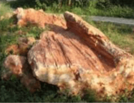
(4) Akal Wood Fossil Park (Jaisalmer)
- Akal Wood Fossil Park is located in Jaisalmer and is one of the most significant fossil parks in India. This national desert park preserves the remains of wood fossils, which have turned to stone over millions of years.
- Geological Significance: The fossils in Akal Wood Fossil Park date back to the Jurassic Period, approximately 180 million years ago. The fossils found here are evidence of the dense forests that once covered the area, before climatic changes transformed the region into the desert it is today.
- Exhibits: The park contains fossilized tree trunks, some of which are as large as 13 meters in length. These fossils are invaluable in studying the ancient history of the region and understanding how the landscape has evolved over millions of years.
Historical Context: The fossils at Akal Wood Fossil Park are from a period when dinosaurs roamed the Earth, and the climate was vastly different from the arid desert environment that now exists in Rajasthan.
(5) Baap Boulder Clay
- Boulder clay refers to sediments and large stones or boulders that were formed through deposition by glaciers or ice sheets. These materials were deposited during glacial periods, and the resulting clay is often compact and includes various sizes of rock fragments.
- Formation Period: The Baap Boulder Clay in the Thar Desert is believed to have been formed during the Permo-Carboniferous period, which occurred approximately 250-280 million years ago. This time frame marks the late Carboniferous and early Permian periods, a time when the Earth was experiencing significant climatic shifts, including glaciations.
- Location: The Baap Boulder Clay is primarily found in the Jodhpur district of Rajasthan, particularly around the village of Baap. This unique geological formation is evidence of the ancient glacial activities that once occurred in this part of the world, long before it transformed into the desert environment we see today.
The above image shows the rocky, sediment-filled structure of the Baap Boulder Clay. These large stones, embedded in clay, are remnants of ancient glacial deposits.
(6) Oasis
- An Oasis is a fertile area in a desert where water is available, typically from underground springs or surface water sources. Oases support vegetation and are critical for both human and animal life in desert environments. They provide a stark contrast to the arid desert landscape surrounding them.
- Oases are often located along routes of ancient trade and travel, serving as vital water stops for caravans and travelers. The availability of water in an oasis makes it possible for plants to grow and for agricultural activities to take place in otherwise barren landscapes.
- Importance: In the Thar Desert, oases are essential for the survival of local communities. They provide drinking water for humans and livestock, as well as opportunities for small-scale farming.
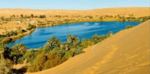
The image shows the typical landscape of the Thar Desert, with shifting and wavy sand dunes shaping the area near water bodies. These dunes create the ever-changing landscape characteristics of desert regions like Jaisalmer.
(6) Dhore and Dharyan (Types of Sand Dunes)
- Dharyan refers to shifting sand dunes, which are sand formations that move and change their location over time due to the action of wind. These dunes are continuously reshaped by the strong desert winds of the Thar, which transport the sand from one place to another.
- Dhore refers to wavy sand dunes, which exhibit a more undulating or wave-like pattern. These dunes have more gentle slopes and are shaped by consistent wind patterns over time.
- Location: Both Dhore and Dharyan dunes are primarily found in the Jaisalmer region, where the wind-driven landscape of the Thar Desert continuously transforms these natural formations. The presence of these types of dunes makes Jaisalmer a unique geomorphological area within Rajasthan.
(7) Reevna (Snake Species)
- Reevna is a species of snake, notable for its yellow color. This snake is primarily found in the Jaisalmer region of Rajasthan. Its unique coloration allows it to blend into the desert surroundings, making it well-adapted to the arid and sandy environment.
- This species of snake, like other desert-dwelling reptiles, has evolved to survive in the extreme conditions of the Thar Desert, where water and food sources are scarce.
(8) March of the Desert
- The March of the Desert refers to the shifting or expansion of desert areas, particularly the movement of sand dunes and desertification from Rajasthan towards the neighboring state of Haryana. This process highlights how the arid conditions of the Thar Desert are spreading beyond traditional desert boundaries, affecting nearby regions.
- Barkhan sand dunes, which are crescent-shaped dunes, are noted for their significant role in contributing to desertification. These dunes are particularly dynamic, meaning they shift rapidly due to strong winds. As they move, they contribute to the degradation of land by covering fertile soil, making it less suitable for agriculture and habitation.
- Impact: The march of the desert represents a critical environmental challenge, as it threatens to transform more regions into arid, uninhabitable landscapes. This has severe consequences for agriculture, biodiversity, and human settlements in areas affected by desertification.
The map shows the direction of desertification, with the expansion of the Thar Desert towards neighboring regions like Haryana. This march represents the environmental challenge of expanding desert areas.
(9) Balson (Water Basins)
- Balson refers to water basins or lakes that are found in the middle of mountains in desert areas. These basins are often seasonal, filling up with water during the monsoon season and drying out during the hot summer months.
- Example: The most well-known example of a balson in Rajasthan is the Sambhar Lake, which is the largest inland saltwater lake in India. Located near Jaipur, Sambhar Lake is a critical water source in the desert and supports both wildlife and salt extraction industries.
- Sambhar Lake also serves as a habitat for various species of migratory birds and is recognized as a Ramsar wetland of international importance.
(10) The Thar Desert
- The Thar Desert is one of the largest deserts in the world and a defining feature of Rajasthan’s geography. Approximately 85% of the Thar Desert is located within India, while the remaining 15% extends into Pakistan.
- Within India, more than 60% of the desert lies within the state of Rajasthan (about 62% of the total desert area). The remaining portion of the Thar Desert extends into the states of Gujarat, Punjab, and Haryana.
- The March of the Desert refers to the gradual expansion of desert conditions, which are moving from Rajasthan into Haryana. This phenomenon is linked to desertification, where formerly fertile land is transformed into arid desert landscapes due to natural processes and human activities.
ARAVALLI MOUNTAIN RANGE
- The Aravalli Range is one of the oldest mountain ranges in the world, dating back to the Precambrian Period, over 2.5 billion years ago. It is a folded mountain range that has been heavily eroded over time, leaving behind residual mountains at present.
- Formation: The Aravallis were formed through a tectonic process when the Indian Plate collided with the Eurasian Plate, creating this ancient mountain range. Over time, the mountains have been reduced to residual hills, remnants of the original high peaks.
- Geography: The total length of the Aravalli Range is approximately 692 kilometers, with about 550 kilometers (80%) of the range lying within Rajasthan.
- Average Height: The average elevation of the Aravalli Range is 930 meters, with Mount Abu being the highest peak at 1,722 meters. Mount Abu is also a popular hill station in Rajasthan and home to the famous Dilwara Temples.
- Significance: The Aravalli Range acts as a natural barrier that prevents the desert from spreading eastwards. It also influences the climate of Rajasthan, creating a rain shadow effect that contributes to the arid conditions in the western part of the state.
Direction of Aravalli
- The Aravalli Range runs in a North-East to South-West direction across Rajasthan. It serves as a natural barrier, influencing both the climate and geography of the state.

In terms of cardinal directions:
- The North-East direction is referred to as Ishanaya.
- The South-West direction is referred to as Nairutya.
The map shows the physical regions of Rajasthan, highlighting the direction of the Aravalli Range as it runs from the northeast to the southwest, separating the Western Desert Plains from the Eastern Plains.
The Aravalli Range extends from the Delhi-Haryana border in the northeast to Gujarat in the southwest, crossing through the heart of Rajasthan.
Study of the Aravalli
The Aravalli Range is divided into three distinct parts based on geographical and geological studies:
- Northern Aravalli
- Middle Aravalli
- Southern Aravalli
Each part is characterized by its own unique geographical features and contains prominent peaks.
(a) Northern Aravalli
- The Northern Aravalli range stretches from Jhunjhunu to Jaipur. This section is home to some of the most well-known peaks in the northern region of Rajasthan.
- Highest Peak:
- Raghunathgarh Peak is the highest in the Northern Aravalli, with an elevation of 1,055 meters. It is located in the Sikar district.
(b) Middle Aravalli
- The Middle Aravalli, also known as the Ajmer Aravalli, is located between the cities of Jaipur and Rajsamand. This part of the range includes the famous pilgrimage town of Ajmer, as well as several historically significant sites.
- Highest Peaks:
- Todgarh Peak, located in the Ajmer area, reaches an elevation of 934 meters.
- Taragarh Peak is another significant peak in the region, rising to 873 meters.
(c) Southern Aravalli
- The Southern Aravalli extends between Rajsamand and Sirohi districts. This is the most rugged and elevated section of the Aravalli range, featuring the highest peaks of the entire range.
- Highest Peak:
- Guru Shikhar is the highest peak of the Aravalli Range, with an elevation of 1,722 meters. It is located in Sirohi, within the famous hill station of Mount Abu. Guru Shikhar is also a major tourist destination due to its religious significance and stunning views.
Geographical Importance of the Aravalli Range
- The Aravalli Range serves as a climatic barrier, preventing the western desert from advancing into the fertile eastern plains. It also plays a crucial role in rainfall patterns, particularly in the eastern parts of Rajasthan.
- Ecologically, the range is home to a variety of flora and fauna, with the southern sections being more densely forested compared to the arid northern regions.
Subdivisions of the Aravalli Range
The Aravalli Range, as part of its complex structure, is further divided into two main parts:
(i) Abu / Aburd Aravalli
- The Abu / Aburd Aravalli is primarily located in the Sirohi and Pali districts of Rajasthan. This section of the range includes the famous hill station Mount Abu, which is a popular tourist destination and the highest point in the entire Aravalli Range.
- Highest Peak:
- The highest peak in this region is Guru Shikhar, located in the Sirohi district. Guru Shikhar stands at 1,722 meters above sea level, making it not only the highest point of the Abu/Aburd Aravalli but also the highest peak in the entire Aravalli Range. This peak holds great religious and cultural significance as well.
(ii) Mewar Aravalli
- The Mewar Aravalli is primarily located in the Udaipur and Rajsamand districts of Rajasthan. This part of the range is more rugged and contains numerous ridges and valleys, which have played a key role in shaping the historical and cultural landscape of the Mewar region.
- Highest Peak:
- The highest peak in this section is Jarga Peak, located near Udaipur. Jarga stands at 1,431 meters and is the tallest peak in the Mewar Aravalli section.
These two subdivisions represent both the geological diversity of the range and the significant role it plays in the environment, culture, and history of Rajasthan.
Table: Highest Peaks of the Aravalli Range
| Trick | Peak Name | Location | Height (Meters) |
|---|---|---|---|
| गुरु से | Guru Shikhar | Sirohi | 1722 |
| से | Sher | Sirohi | 1597 |
| दिल से | Delwara | Sirohi | 1442 |
| जरगा | Jarga | Udaipur | 1431 |
| आस | Achalgarh | Sirohi | 1380 |
| कुंभा | Kumbhalgarh | Rajsamand | 1224 |
| रघुनाथगढ़ | Raghunathgarh | Sikar | 1055 |
| ऋषिकेश | Rishkesh | Sirohi | 1380 |
| का | Kamalnath | Udaipur | 1001 |
| सज्जन | Sajjangarh | Udaipur | 938 |
| मोरं | Moramji / Todgarh | Ajmer | 934 |
| खो | Kho | Jaipur | 920 |
| सैरा | Saira | Udaipur | 900 |
| तारा | Taragarh | Ajmer | 873 |
| बिली | Bilali | Alwar | 775 |
| रोजा | Roja Bhakar | Jalore | 730 |
Key Observations from the Table:
- Guru Shikhar in Sirohi district is the highest peak of the entire Aravalli Range, standing at 1,722 meters. This peak is located in the Mount Abu region and is a popular tourist and pilgrimage site.
- The second highest peak is Sher, also located in Sirohi, with an elevation of 1,597 meters.
- Delwara and Achalgarh are two other notable peaks in the Sirohi district, with heights of 1,442 meters and 1,380 meters, respectively.
- Jarga Peak in Udaipur stands at 1,431 meters, making it the highest point in the Mewar Aravalli region.
- Kumbhalgarh, located in Rajsamand, is a historically important peak and fort at an elevation of 1,224 meters.
- Raghunathgarh in Sikar district is the highest peak in the northern part of the Aravalli Range, with a height of 1,055 meters.
- Taragarh in Ajmer is another historically significant location, with a peak elevation of 873 meters.
- Bilali in Alwar and Roja Bhakar in Jalore are among the smaller peaks, with heights of 775 meters and 730 meters, respectively.
Additional Notes:
|
Passes / Col / Naal of Aravalli
- Passes (also known as Col or Naal) in the Aravalli Range refer to lower and narrow pathways located between mountain ridges. These passes serve as natural connections between the two sides of the mountain range and have historically been significant for trade, travel, and strategic military purposes.
- The passes in the Aravalli Range are crucial for allowing transportation and communication across the mountainous terrain. They form natural corridors through which people, goods, and animals can pass, avoiding the high peaks and ridges.
Diagram Explanation: The diagram shows a simplified representation of a pass or Naal between mountain ridges, highlighting how the pass serves as a lower, navigable pathway through the higher terrain.
Example: Historically, some of these passes have been used by ancient armies or traders to traverse the Aravalli Range, particularly in areas where the terrain is too rugged for easy movement.
- Passes or Naals are lower, narrow pathways through mountain ridges that allow for easier travel between two sides of a mountain range. These Naals have played historical roles in facilitating trade, military movement, and local transport.
Notable Naals in the Aravalli Range:
- Pagalya Naal:
- Connection: This pass connects Marwar (Pali) with Mewar (Rajsamand).
- Bar Naal:
- Connection: Bar Naal connects Pali (Bar) to Ajmer (Beawar).
- Other Significant Naals:
- Dhebar Naal, Kewda Naal, Phulwari ki Naal, Hathi Naal (all located around Udaipur).
- Parwantra Naal, Sura Naal, Someshwar Naal, Hatti Guda Naal, Kamli / Khaniji Naal, Goram Ghat, Teelwa Naal are additional passes connecting various regions in and around Rajsamand, Pali, Ajmer, and Udaipur.
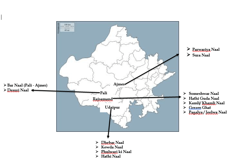
Map Explanation: The map in the image shows the major passes in the Rajsamand, Ajmer, Pali, and Udaipur districts of Rajasthan. These Naals facilitate movement and trade between the Mewar and Marwar regions.
Plateau of Aravalli:
- Udiya Plateau
- The Udiya Plateau is located in the southern part of the Aravalli Range, in the Sirohi district. This plateau is the highest plateau in the state of Rajasthan.
- Elevation: The Udiya Plateau stands at an elevation of 1,360 meters, making it a prominent feature of the Aravalli landscape.
- Geographical Significance: The plateau forms a part of the southern Aravalli range, and its height makes it significant for local weather patterns and biodiversity. It is located near Mount Abu, which is the highest peak region in Rajasthan.
- Abu Block:
- The Abu Block is a plateau located in the southern Aravalli Range, specifically in the Sirohi district.
- Height: The Abu Plateau stands at an elevation of 1,200 meters.
- Geological Importance: The Abu Block is an example of a batholith structure, which is a large mass of igneous rock that has solidified beneath the surface of the earth.
- Bhorat:
- The Bhorat Plateau is located in the Southern Aravalli range, stretching from Udaipur (Gogunda Hills) to Rajsamand (Kumbhalgarh Hills).
- Height: The Bhorat Plateau has an elevation of 1,225 meters.
- Bhomat:
- The Bhomat Plateau is a plateau and hilly region located between Udaipur and Dungarpur.
- Cultural Importance: The Bheel tribe is predominantly found in this region, playing a key role in the culture and demographics of the area.
- Lassadiya:
- The Lassadiya Plateau is located to the east of Jaisamand Lake, in the Southern Aravalli range, within the Udaipur district.
- This plateau is a badland plateau, meaning it is characterized by heavily eroded landforms with little to no vegetation.
- Kakanvadi & Kranska Plateaus:
- These plateaus are located in the Alwar district, within the Sariska Sanctuary. The Sariska region is known for its wildlife and forest reserves.
Importance of the Aravalli Range
- Barrier for Desertification: The Aravalli Range acts as a natural barrier against desertification. It helps prevent the Thar Desert from expanding eastward into more fertile regions of Rajasthan.
- Biodiversity: The Aravalli Range is home to the maximum biodiversity in Rajasthan due to its extensive vegetation cover. The variety of plant life supports diverse ecosystems and wildlife.
- Water Divide of Rajasthan: The Aravalli Range functions as the water divide of Rajasthan. It separates the drainage systems of the state into two distinct parts:
- Rivers flowing eastward towards the Yamuna Basin.
- Rivers flowing westward towards the Arabian Sea.
- Origin of Rivers: Many important rivers of Rajasthan originate from the Aravalli Range. These rivers provide essential water resources for agriculture, drinking, and industry in the region.
- Shelter of Tribes: The Aravalli Range is historically known as a shelter of tribes, especially the Bheel tribe, which has lived in the mountainous and forested regions for centuries.
- Tourism: The Aravalli Range is famous for its tourism potential, with notable locations such as Mount Abu, the only hill station in Rajasthan, being a key tourist destination.
- Cradle of Ancient and Modern Civilization: The Aravalli region is referred to as the “motherland” of both ancient and modern civilizations. Ancient settlements such as Aahad, Bairath, Ganeshwar, and Gilund are found here, as well as modern cities like Jaipur, Ajmer, and Udaipur.
- Mineral Resources: The Aravalli Range is rich in metallic minerals, particularly due to the presence of Dharwar rocks, which are known for containing valuable mineral deposits. This makes the region an important source of natural resources for mining and industrial activities.
The Aravalli Range is not only geologically significant due to its ancient origins and structural features, such as the plateaus and batholiths found in the Abu Block, but it also plays an essential role in environmental protection, biodiversity, water resources, and tribal cultures in Rajasthan. It acts as a natural barrier against desertification, supports a wide range of wildlife, and provides fertile land for agriculture. Additionally, the range has immense historical and cultural significance as the cradle of ancient civilizations and is rich in mineral resources.
Why is Aravalli called the “Planning Region” of Rajasthan?
The Aravalli Range is referred to as the “Planning Region” of Rajasthan because a significant portion of the state’s annual budget is allocated to activities and projects related to areas connected with the Aravalli. These include:
- Tribal Areas: Many tribal communities reside in the Aravalli region, and state planning involves providing them with resources for development and welfare.
- River-Valley Projects: The rivers originating from the Aravalli Range support irrigation and water supply systems, making river-valley projects a key part of state planning.
- Lake Conservation: The lakes in the Aravalli region, particularly around Udaipur and other parts of Rajasthan, are essential for water supply and tourism, and their conservation is a priority.
- Mining: The Aravalli region is rich in minerals, and mining activities are crucial for the state’s economy. Planning related to sustainable mining practices is a focus area.
- Urban Development: Several cities near the Aravalli, such as Jaipur, Ajmer, and Udaipur, require urban planning for infrastructure and growth.
- Tourist Places: The Aravalli Range is home to several popular tourist destinations, including Mount Abu, Udaipur, and Ajmer, necessitating planning for tourism development.
- Biodiversity Areas: The forests and wildlife in the Aravalli region contribute to the state’s biodiversity. Conservation efforts for flora and fauna are an essential part of planning.
These factors make the Aravalli Range a central focus of economic and environmental planning in Rajasthan, hence its title as the “Planning Region.”
Key Points
|
Geological Study of the Aravalli Range by A.M. Heron
- A.M. Heron, a notable geologist, conducted significant studies on the geomorphic structure of the Aravalli Range in Rajasthan. His work focused on understanding the formation, composition, and geological history of this ancient mountain range.
- According to Heron, the Aravalli Range was formed as part of the Delhi Supergroup, a collection of metamorphic rocks that developed during the Precambrian era.
Delhi Supergroup
The Delhi Supergroup consists of three main groups of geological formations, which were identified and studied by A.M. Heron:
- Alwar Group: This group consists of ancient rocks found primarily in the Alwar region of Rajasthan.
- Ajabgarh Group: The Ajabgarh Group includes metamorphic rocks found in areas around Ajabgarh, which are a part of the larger Aravalli geological structure.
- Raialo Group: The Raialo Group refers to another set of metamorphic formations found in specific areas of the Aravalli range.
Heron’s classification helps geologists understand the complex rock systems of the Aravalli Range, which is considered one of the oldest mountain ranges in the world.
IMPORTANT HILLS OF RAJASTHAN AND THEIR LOCATIONS
In Rajasthan, several hills and mountain ranges play important roles in the geography and culture of the region. Below is a list of some key hills and their locations:
| Hill / Mountain | Location | Additional Information |
| Trikoot Hills (Sonar Fort) | Jaisalmer | |
| Trikoot Parvat (Kaila Devi Temple) | Karoli | |
| Chidiva Took (Mehrangarh Fort) | Jodhpur | |
| Chappan Hills (Circular Hill) | Barmer (Sivana) | |
| Roja Bhakar | Jalore | |
| Israna Bhakar | Jalore | |
| Iharola Bhakar | Jalore | |
| Iswantpura Hills (Dora Mountain – highest peak) | Jalore | |
| Sundha / Sunda Mountain | Jalore | |
| Bhakar | Sirohi | |
| Bel ka Magra | Sirohi | |
| Moti Magri (Fateh Sagar) | Udaipur | |
| Hiran Magri | Udaipur | |
| Machhla Magra (2nd Ropeway – 2008) | Udaipur | |
| Jarga Hills | Udaipur | |
| Raga Hills | Udaipur | |
| Gogunda Hills | Udaipur | Origin of Aavad / Bedach River |
| Bichhameda Hills | Udaipur | Origin of Som River |
| Rail Ka Magara | Rajsamand | |
| Bijraal Hills | Rajsamand | Origin of Khari River |
| Diwer Hills | Rajsamand | Origin of Kothari River |
| Khammore Hills | Rajsamand | Origin of Banas River |
| Naag Hills | Ajmer | Origin of Luni River |
| Moti Dungri | Jaipur | |
| Jhalana Dungri | Jaipur | |
| Mahadev Dungri | Jaipur | |
| Ganesh Dungri | Jaipur | |
| Bheem Dungri | Jaipur | |
| Beejak Dungari | Jaipur | |
| Manoharpur Hills | Jaipur | |
| Sevar Hills | Jaipur | Origin of Sabi River |
| Bairath Hills | Jaipur | Origin of Banganga River 704 meters elevation |
| Barwada Hills | Jaipur | |
| Chauth Ka Barwara | Sawai Madhopur | Temple of Chauth Mata known for Lead and Zinc Storage |
| Baabai Hills | Jaipur | |
| Babai Hills | Jhunjhunu | |
| Cheel ka Teela (Eagle’s Hills) | Jaigarh Jaipur | |
| Harsh Hills | Sikar | |
| Maalkhet Hills | Sikar | Origin of Kantali River known for Uranium Storage |
| Khandela Hills | Sikar | Origin of Ruparel River |
| Udaynath | Alwar | |
| Harshnath Hills | Alwar |
Note: Desharo Region
Desharo is described as a greenery region located between Jarga and Raga Hills in Udaipur. This suggests that Desharo is an area with significant vegetation, possibly due to the presence of water sources or favorable geographical conditions. Udaipur is known for its lakes and green areas, making regions like Desharo important for maintaining the ecological balance of the area.
Significance of the Listed Hills
- Geographical Importance: Several hills in this list are significant due to the origin of rivers. For instance, the Naag Hills are the origin of the Luni River, while the Khammore Hills give rise to the Banas River. These rivers are critical for the agricultural and ecological sustenance of Rajasthan.
- Cultural and Religious Importance: Moti Dungri, Ganesh Dungri, and Jhalana Dungri are famous hills in Jaipur known for their religious significance. These hills are home to important temples and pilgrimage sites.
Chauth Ka Barwara in Sawai Madhopur is not only known for the Chauth Mata Temple but also for being a site rich in Lead and Zinc deposits.
- Mining and Resources: Khandela Hills in Sikar are notable for containing Uranium deposits, making them a strategically important location for resource extraction.
Other hills, such as Chauth Ka Barwara, also hold significant mineral deposits.
- Historical and Architectural Importance: Cheel ka Teela (Eagle’s Hills) in Jaigarh is famous for its historical significance, as it is located near the Jaigarh Fort. The fort houses a large cannon and offers panoramic views of Jaipur.
Bairath Hills in Jaipur are known for their historical connections to ancient settlements and the presence of Buddhist stupas.
The hills and mountains listed in the text are not only important from a geographical perspective but also hold significance in religious, historical, and economic contexts. Several of these hills are the origins of key rivers that sustain Rajasthan’s agriculture and ecology. Others are centers of mineral wealth or contain sacred temples, making them important cultural landmarks. The Desharo region, located between Jarga and Raga Hills, adds ecological diversity to the area with its greenery.
These hills contribute to the geographical diversity of Rajasthan and play an essential role in shaping the state’s cultural, historical, and economic landscape.
Types of Hills in Rajasthan
- Circular Hills
- Location: Barmer
- These hills have a circular formation, where the hill structure forms a closed or rounded shape.
- Horse-Shoe Type Hills
- Location: Ramgarh-Baran
- These hills are shaped like a horse shoe, with an open, U-shaped curve.
- Disc or Girwa Hills
- Location: Udaipur
- These hills are shaped like a disc or bowl, and are referred to as Girwa Hills in the Udaipur region. Udaipur City is located within these Girwa Hills.
- Crescent-Shaped Hills
- Location: Bundi, Kota, and Jhalawar
- These hills are curved like a crescent moon, creating an arcing shape that is distinct to these regions.
- Naag / Snake-Type Hills
- Location: Ajmer
- These hills are referred to as Naag (Snake)-Type Hills because their shape resembles a serpentine or snake-like curve. This formation is commonly found in the Ajmer region.
The image highlights several types of hill formations found across different parts of Rajasthan. These formations are primarily classified based on their shapes, which have developed due to the region’s unique geomorphology.
Girwa Hills
- Girwa refers to a series of disc-shaped hills located in the Udaipur region. Udaipur City itself is nestled in these hills, giving the city its unique topography and scenic views. The Girwa Hills create a bowl-like structure around Udaipur, contributing to the area’s famous lakes and greenery.
Piedmont Hills
- Piedmont refers to an area at the base of a mountain or mountain range, which is formed by erosion over time. The deposition of eroded materials from the mountains creates the piedmont plains.
- In Rajasthan, the Piedmont Hills are located in the Devgarh region of Rajsamand district. These hills are primarily a result of the erosion of the surrounding mountain ranges.
EASTERN PLAIN OF RAJASTHAN
- The Eastern Plain is a geographical area formed by the deposition of river sediments. Over time, rivers flowing through the region deposit alluvial materials, which results in fertile plains.
- The Pleistocene Period is noted as the formation time for the Eastern Plains. The Pleistocene era is a geological time period that occurred around 2.58 million years ago to 11,700 years ago, during which significant climatic changes contributed to the shaping of the landscape.
Study of the Eastern Plain
The Eastern Plain of Rajasthan is divided into three distinct parts based on geographical and geological studies:
- Mahi Plain
- The Mahi Plain, also known as the Vagad / Bhati Plain, is located in the southern part of Rajasthan.
- Extension: The Mahi Plain extends across the districts of Banswara, Pratapgarh, and Dungarpura.
- Alternative Names: In regions like Banswara and Pratapgarh, the Mahi Plain is also referred to as Chhapan Plain.
- Soil: The Mahi Plain is characterized by red loamy soil, which is fertile and supports various crops.
- Agricultural Production:
- Maize and rice are the major crops produced in the Mahi Plain.
- Popular varieties of crops include:
- Rice: Mahi Sugandha
- Maize: Mahi Kanchan and Mahi Dhawal
- Banas and Banganga Plain
The Banas and Banganga Plain is further divided into different parts based on geographical characteristics:
(i) Banas Plain:
The Banas Plain is divided into two parts:
(a) Mewar Plain: The Mewar Plain refers to the southern plain of the Banas River. It extends across the districts of Rajsamand, Bhilwara, and Chittorgarh.
(b) Maalpura-Karoli Plain: The Maalpura-Karoli Plain refers to the northern plain of the Banas River, extending into Ajmer, Swaimadhopur, and Tonk districts.
Soil: Brown soil is primarily found in the plains of Banas.
(ii) Banganga Plain: The Banganga Plain is located in Jaipur, Dausa, and Bharatpur districts. This area is characterized by fertile alluvial soil, making it a productive region for agriculture.
- Chambal Plain
The Chambal Plain is another key section of the Eastern Plains of Rajasthan. Though the specific details of the Chambal Plain are not provided in the image, it is generally known for its proximity to the Chambal River, which flows through Rajasthan, Madhya Pradesh, and Uttar Pradesh.
- The Chambal River is famous for its deep gorges and ravines, which contribute to the unique landscape of the plain. The area is also known for its rich biodiversity, including endangered species like the gharial (a type of crocodile) and the gangetic dolphin.
- The Chambal Plain is referred to as a Ravines / Dang Plain due to its unique terrain. This plain is characterized by deep ravines formed as a result of gully erosion caused by the Chambal River. The process of gully erosion creates narrow and deep channels in the land, making the terrain rough and difficult for agriculture.
- Extension: The Chambal Plain extends into the districts of Kota, Bundi, Karoli, Dholpur, and Swaimadhopur. These regions are known for their rugged landscapes due to the erosional effects of the Chambal River and its tributaries.
- The Chambal River is one of the major rivers flowing through Rajasthan, and it is known for its dramatic gorges and ravines, which are a result of long-term erosion.
Other Important Points: Population Density in the Eastern Plain
|
Plains of Rajasthan (Direction-wise)
The image provides a map showing the major plains of Rajasthan, classified according to their geographical location. These include:
- Indus Plain: Located to the west of Rajasthan, adjacent to the Indus River basin.
- Luni Plain: Situated in the western part of the state, this plain is influenced by the Luni River, which flows through the arid regions of Rajasthan.
- Mahi Plain: Found in the southern part of the state, as discussed earlier, this plain is influenced by the Mahi River and extends into Banswara and Pratapgarh.
- Ghaggar Plain: Located in the northern part of Rajasthan, influenced by the Ghaggar River, which is a seasonal river flowing through the Thar Desert
- Chambal Plain: In the southeastern part of the state, characterized by the ravines formed by the Chambal River.
- Yamuna Plain: This plain lies to the east, adjacent to the Yamuna River, which forms the border between Rajasthan and neighboring states like Haryana and Uttar Pradesh.
SOUTH-EASTERN PLATEAU / HADOTI PLATEAU (MAAL REGION)
- The South-Eastern Plateau of Rajasthan is also known as the Hadoti Plateau or the Maal Region. This region is known for its rugged terrain, which consists of hills and plateaus that are part of the larger Deccan Plateau system.
- Geographical Extension: The Hadoti Plateau extends into the districts of Kota, Bundi, Baran, and Jhalawar. The region is rich in natural resources and is known for its historical significance.
- Soil: The plateau is composed of red and black soil, which is suitable for growing crops like soybean, wheat, and millets.
- Climate and Agriculture: The Hadoti Plateau region has a semi-arid climate with distinct rainy and dry seasons. The region benefits from the flow of the Chambal River, which helps in irrigation and supports agriculture.
- The Hadoti Plateau, also known as the South-Eastern Plateau of Rajasthan, is a significant geological and geographical feature, formed by basalt lava from volcanic eruptions.
- Formation: The Hadoti Plateau was formed through the basalt lava flows from volcanic eruptions, making it part of the Deccan Trap region.
- Time Period: The formation of the Hadoti Plateau dates back to the Cretaceous Period (approximately 145 to 66 million years ago), when intense volcanic activity contributed to the formation of large basaltic plateaus.
- Soil: The Hadoti Plateau region is characterized by light black soil, which is fertile and suitable for growing crops like cotton and soybeans.
Study of the Hadoti Plateau
According to geographical and geological studies, the Hadoti Plateau is divided into two major divisions:
(i) Deccan Lava Plateau
- Extension: The Deccan Lava Plateau extends into the Malwa and Uparmal regions, which are part of the greater Deccan Plateau system.
- Sub-Divisions:
- Malav Region: The Malav Region includes the districts of Pratapgarh and Jhalawar, which are part of the Malwa Plateau.
- Uparmal Region: The Uparmal Region is a plateau region that extends from Bhilwara (Bijolia) to Chittorgarh (Bhainsrorgarh). This region features rugged plateaus and is rich in minerals.
(ii) Vindhyan Scarpland
- The Vindhyan Scarpland extends into the Hadoti and Dang regions, covering a wide area of Kota, Bundi, Jhalawar, Bara, Karoli, Dholpur, and Swaimadhopur districts.
- Geological Features:
- The Vindhyan Scarpland is rich in rocks and minerals, including:
- Sandstone (Maximum)
- Limestone
- Kota Stone
- Red Stone
- Diamond
- The Vindhyan Scarpland is rich in rocks and minerals, including:
These minerals make the region geologically important, especially for the construction and stone industries.
Great Boundary Fault
- The Great Boundary Fault is a significant geological feature located between the Hadoti Plateau and the Aravalli Range. It represents a fault line, which is a break or fracture in the Earth’s crust along which movement has occurred.
- Extension: The Great Boundary Fault extends across the districts of Chittorgarh, Bhilwara, Bundi, Karoli, Dholpur, and Swaimadhopur.
- Geological Importance: The fault line separates the Vindhyan Scarpland from the Aravalli Range, creating a distinct geological boundary that has influenced the topography and structure of Rajasthan.
Subdivisions of Hadoti Plateau
The Hadoti Plateau is a geographically diverse region in southeastern Rajasthan, and the newly mentioned subdivisions highlight the specific uplands and hills within this plateau. These subdivisions are part of the greater geological and geographical structure of Hadoti.
(i) Crescent Shape Hills
- The Crescent Shape Hills include the Bundi Hills and Mukundra Hills, which are known for their distinct crescent-like formations.
- Location: These hills are primarily found in the regions of Bundi, Kota, and Jhalawar. The crescent shape refers to the arched, half-moon-like formation of the hills, which is typical of this region.
(ii) Shahabad Upland
- The Shahabad Upland is characterized by horse-shoe-shaped hills, which are also common in the Ramgarh-Baran region.
- Tribal Population: The Saharia tribe is primarily found in the Shahabad region. The Saharia are a forest-dwelling tribe that have historically inhabited the uplands of the Shahabad region.
(iii) Dag-Gangdhar Upland
- The Dag-Gangdhar Upland is another subdivision of the Hadoti Plateau, located in Jhalawar district. This upland is characterized by elevated landforms and rolling terrain, contributing to the overall topographical diversity of Hadoti.

The diagram in the image represents the three major subdivisions of the Hadoti Plateau:
- Crescent Shape Hills (located in Bundi, Kota, and Jhalawar)
- Shahabad Upland (covering the Ramgarh-Baran region and home to the Saharia tribe)
- Dag-Gangdhar Upland (located in Jhalawar)
These subdivisions reflect the varied topography of the Hadoti Plateau, with its crescent-shaped hills, uplands, and horse-shoe-type hills.