
LOCATION AND EXTENSION OF RAJASTHAN
Rajasthan, the largest state of India in terms of area, holds a significant geographical position in the north-western part of the country. Let’s break down its location and extension with more detailed information.
- Location of Rajasthan
Rajasthan is located in the north-western part of India, occupying a strategic position both in the Northern Hemisphere and Eastern Hemisphere.
- Latitude and Longitude:
- Rajasthan stretches between 23°30’N and 30°12’N latitude.
- It extends between 69°30’E and 78°17’E longitude.
This positioning places Rajasthan well within the subtropical zone of India, which contributes to its arid and semi-arid climate.
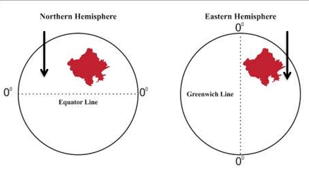
In this visual, Rajasthan is depicted as located between the Equator (0° latitude) and the Tropic of Cancer, showing its exact positioning on the globe.
- Extension of Rajasthan
- Area: Rajasthan covers an area of 342,239 square kilometers, making it the largest state in India by area. This vast expanse contributes to its diverse geography, ranging from the Thar Desert in the west to the Aravalli Range in the central part of the state.
- Shape: The state has an irregular shape. Its western part is dominated by desert landscapes, while the eastern side has more diverse geographical features, including forests and rivers.
- Boundary: Rajasthan shares its borders with five Indian states:
- Punjab to the north,
- Haryana and Uttar Pradesh to the northeast,
- Madhya Pradesh to the southeast,
- Gujarat to the southwest.
Additionally, Rajasthan has an international border with Pakistan to the west, stretching for around 1,070 kilometers, making it a strategically important state in India’s defense structure.
Geographical Importance of Rajasthan
Rajasthan’s unique location and size influence several key aspects:
- Climatic Diversity: Due to its vast latitudinal and longitudinal extent, Rajasthan experiences climatic extremes—from the dry, arid conditions of the Thar Desert to relatively moderate climates in the eastern region.
- Strategic Importance: With a long international border with Pakistan, Rajasthan is vital in terms of India’s defense, housing key military installations in its desert regions.
- Cultural and Economic Impact: The state’s positioning at the crossroads of several historical trade routes has contributed to its rich cultural heritage and the development of cities like Jaipur, Jodhpur, and Udaipur as major economic and tourism hubs.
Additional Facts and Data
- Rajasthan constitutes 10.4% of the total geographical area of India.
- Its arid desert landscape, particularly the Thar Desert, contributes significantly to its climatic conditions, which are predominantly dry and hot.
KEY GEOGRAPHICAL COORDINATES AND FACTS ABOUT RAJASTHAN
| Feature | Details |
|---|---|
| Total Area | 342,239 sq. km |
| Latitude Range | 23°30’N to 30°12’N |
| Longitude Range | 69°30’E to 78°17’E |
| International Border Length | 1,070 km (with Pakistan) |
| States Sharing Boundaries | Punjab, Haryana, Uttar Pradesh, Madhya Pradesh, Gujarat |
| Largest District by Area | Jaisalmer |
| Smallest District by Area | Dholpur |
Latitudinal and Longitudinal Location of Rajasthan
(a) Latitudinal Location of Rajasthan
Rajasthan, extending from the southern to northern part, covers a significant range in terms of latitude. The latitudinal extension of the state is crucial in defining its climate, agricultural patterns, and daylight duration.
- Latitude Range:
- Southernmost point: 23°3’N (Borkunda Village, Banswara District)
- Northernmost point: 30°12’N (Kona Village, Sri Ganganagar District)
Distance Covered:
- The latitudinal distance between the southernmost point in Borkunda, Banswara and the northernmost point in Kona Village, Sri Ganganagar is approximately 826 kilometers.
This wide latitudinal extension contributes to varying climatic conditions within the state, ranging from arid deserts in the north-western region to more moderate climates in the south.
Below is a map illustrating the latitudinal span of Rajasthan from Borkunda (Banswara) to Kona (Sri Ganganagar):
Additional Facts:
- Latitude Gap of Rajasthan: The latitudinal difference from north to south is 7°09′.
- Tropic of Cancer:
- The Tropic of Cancer passes through the southern part of Rajasthan, particularly through Banswara and Dungarpur districts.
- The total length of the Tropic of Cancer within Rajasthan is approximately 26 kilometers.
Special Note – June 21st:
- 21st June is the longest day in the Northern Hemisphere, including Rajasthan, as it marks the Summer Solstice. On this day, the state experiences the maximum daylight hours.
- Since 2015, this day has been recognized and celebrated as International Yoga Day.
(b) Longitudinal Location of Rajasthan
In addition to its latitudinal span, Rajasthan also has a wide longitudinal range, influencing time zones, sunrise and sunset timings, and the overall positioning of the state from west to east.
- Longitude Range:
- Westernmost point: 69°30’E (Katra Village, Jaisalmer District)
- Easternmost point: 78°17’E (Silana Village, Dholpur District)
Distance Covered:
- The longitudinal distance from Katra Village in Jaisalmer (west) to Silana Village in Dholpur (east) is around 826 kilometers.
Below is a map illustrating the longitudinal span of Rajasthan from Katra (Jaisalmer) to Silana (Dholpur):
Additional Facts:
- Longitude Gap of Rajasthan: The longitudinal difference from west to east is 8°47′, which reflects the wide expanse of the state in terms of time zones and daylight variation across regions.
Impact of Latitude and Longitude on Rajasthan
The vast latitudinal and longitudinal span of Rajasthan has a notable impact on various aspects of life in the state, including:
- Climatic Variation:
- The northern parts of Rajasthan experience more extreme temperatures due to proximity to the Thar Desert.
- The southern regions, especially near the Aravalli Range, experience relatively milder weather, with increased rainfall compared to the arid north-west.
- Agricultural Diversity:
- Due to the varying climate across the latitudinal range, Rajasthan produces a wide range of crops, from millets and barley in the arid north-west to wheat and pulses in the eastern regions.
- Cultural Diversity:
- The different geographical conditions across the state contribute to the cultural diversity of Rajasthan. While the Marwari culture dominates the western desert regions, the Mewar and Hadoti cultures thrive in the more fertile and forested southern and eastern parts of the state.
- Economic Activities:
- The desert regions in the north-west primarily rely on tourism and livestock rearing.
- In contrast, the southern regions, due to better access to water, have a stronger agricultural economy.
LATITUDINAL AND LONGITUDINAL COORDINATES OF RAJASTHAN
| Coordinates | Northernmost Point | Southernmost Point | Westernmost Point | Easternmost Point |
|---|---|---|---|---|
| Latitude | 30°12’N (Kona, Sri Ganganagar) | 23°3’N (Borkunda, Banswara) | – | – |
| Longitude | – | – | 69°30’E (Katra, Jaisalmer) | 78°17’E (Silana, Dholpur) |
| Distance | 826 kilometers | – | 826 kilometers |
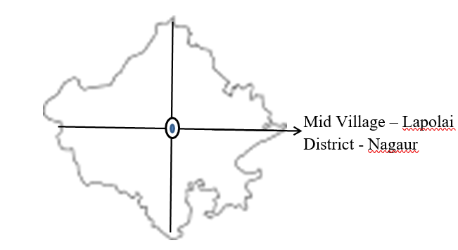
Mid Village of Rajasthan
The geographical midpoint of Rajasthan, determined by satellite surveys, is the village of Lapolai in the Nagaur District.
- Mid Village:
- Location: Lapolai, Nagaur District
- Geographical Importance: The mid village of a state helps in understanding its central point, which can be useful for administrative, geographical, and infrastructural purposes.
This midpoint symbolizes the heart of Rajasthan, connecting the various extremes of the state both longitudinally and latitudinally.
Below is a map indicating the mid-point (Lapolai) of Rajasthan:
(ii) Longitudinal Time Difference in Rajasthan
The longitudinal span of Rajasthan has practical implications on the time difference between the easternmost and westernmost points. Each degree of longitude accounts for a time difference, which becomes significant in a state as large as Rajasthan.
- 1° Longitude = 4 Minutes
- 1′ (minute of) Longitude = 4 Seconds
Given the longitudinal difference between Dholpur (East) and Jaisalmer (West), the time gap is approximately 35 minutes and 8 seconds. This time difference is due to the wide longitudinal span of the state, which stretches across 8°47′ of longitude.
Extension of Rajasthan
The extension of Rajasthan covers various aspects such as area, shape, and boundary. Let’s delve deeper into each:
(a) Area
- Rajasthan is the largest state in India in terms of area, occupying a significant part of the country’s geographical space. It spans over 342,239 square kilometers (or 132,139.8 square miles).
- Percentage of India’s Total Area: Rajasthan covers about 10.41% of the total land area of India (as of 1st November 1956). This makes it a dominant state not only in terms of size but also in terms of its strategic and economic significance.
Note:
- According to area rankings as of 1st November 2000, Rajasthan ranks first among Indian states in terms of its total area.
(b) Shape
The shape of Rajasthan is irregular, characterized by:
- Desert regions in the west,
- Mountainous regions of the Aravalli Range running from southwest to northeast,
- Plains and river basins in the east.
Rajasthan’s distinct shape reflects its geographical diversity, with varying landscapes from deserts to forests, rivers, and mountains.
(c) Boundary
Rajasthan shares its borders with five Indian states and an international boundary with Pakistan. The boundary distribution is as follows:
- Domestic Boundaries:
- Punjab to the north,
- Haryana and Uttar Pradesh to the northeast,
- Madhya Pradesh to the southeast,
- Gujarat to the southwest.
- International Boundary:
- Pakistan to the west, stretching approximately 1,070 kilometers.
The strategic location of Rajasthan along the India-Pakistan border makes it an essential part of India’s defence system, with key military installations and desert warfare training centres located here.
Geographical Divisions and Boundaries of Rajasthan
(a) Largest and Smallest Districts of Rajasthan
Rajasthan is not only the largest state in India but also contains some of the largest districts in terms of area. The state is divided into 33 districts, which vary significantly in size.
Additional Facts:
Comparison with Other Countries: Rajasthan’s total area is comparable to or exceeds the size of several countries. For instance:
(b) Shape of Rajasthan Geographically, Rajasthan has a unique and distinct shape that has been described as “rhombus-shaped” by T.H. Handley. This shape is also colloquially referred to as kite-shaped due to its broad expanse with tapering ends. The state’s irregular yet identifiable shape plays a key role in influencing its climatic conditions, geographical diversity, and even cultural regions. Total Boundary Length:
Boundaries of Rajasthan Rajasthan’s extensive boundary includes both international and interstate limits. The state plays a crucial role in India’s border security, sharing a significant portion of its boundary with Pakistan, as well as with neighboring Indian states. A. International Boundary of Rajasthan Rajasthan shares its international boundary with Pakistan, which covers a substantial portion of its total border.
|
The following diagram shows the international boundary of Rajasthan, highlighting the key districts and Pakistani provinces it borders:
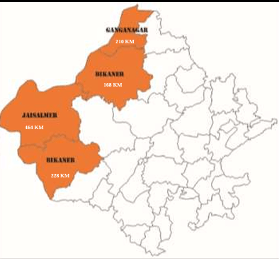
Important Points:
- Sri Ganganagar is the nearest district headquarters to the international boundary with Pakistan.
- Bikaner is the farthest district headquarters located near the international boundary.
- Dholpur is the farthest district headquarters from the international boundary.
- Interstate Boundary of Rajasthan
Apart from its international boundary, Rajasthan also shares an extensive boundary with several neighboring Indian states. These boundaries are crucial for domestic connectivity, trade, and cultural exchange.
- Neighboring States: Rajasthan shares its borders with five Indian states:
- Punjab to the north,
- Haryana and Uttar Pradesh to the northeast,
- Madhya Pradesh to the southeast,
- Gujarat to the southwest.
- Length of Interstate Boundary:
- The total length of Rajasthan’s interstate boundary is approximately 4,850 kilometers, which accounts for a large portion of its overall geographical expanse.

Total Boundary Length
- The combined length of Rajasthan’s international and interstate boundaries is 5,920 kilometers, making it one of the longest boundary stretches among Indian states. This geographical positioning plays a pivotal role in both the state’s strategic importance and its interactions with neighboring regions.
| Note on the Strategic Importance of the Boundary
Rajasthan’s international boundary with Pakistan holds immense strategic importance. Key military installations and border defense mechanisms are positioned along the Thar Desert, particularly in the districts of Jaisalmer, Barmer, and Sri Ganganagar. The desert terrain provides both challenges and opportunities for India’s border security. |
Interstate Boundary of Rajasthan
Rajasthan shares borders with five neighboring Indian states. These boundaries not only affect interstate commerce, connectivity, and cultural exchange but also play a role in regional politics and defense strategies.
NEIGHBOURING STATES AND THEIR BOUNDARIES WITH RAJASTHAN
| Neighbouring State | Boundary Length (in km) | Districts of Rajasthan Sharing the Boundary | Note |
|---|---|---|---|
| Madhya Pradesh | 1,600 km | Dholpur, Karauli, Sawai Madhopur, Bhilwara, Banswara, Baran, Jhalawar, Pratapgarh, Chittorgarh | Madhya Pradesh shares the longest boundary with Rajasthan, covering nine districts. The geographical terrain along this boundary is diverse, including forested regions, hills, and river basins. |
| Haryana | 1,262 km | Jaipur, Bharatpur, Hanumangarh, Alwar, Churu, Sikar, Jhunjhunu | Rajasthan’s boundary with Haryana passes through important urban centers and agricultural regions, making this boundary crucial for trade and infrastructure development. |
| Gujarat | 1,022 km | Jalore, Banswara, Barmer, Udaipur, Sirohi, Dungarpur | Gujarat’s boundary with Rajasthan spans six districts, covering desert regions, hills, and tribal areas, contributing to both cultural exchanges and agricultural activities along the border. |
| Uttar Pradesh | 877 km | Bharatpur, Dholpur | Although relatively shorter in length compared to other neighboring states, the boundary between Uttar Pradesh and Rajasthan plays a vital role due to its proximity to the National Capital Region (NCR). |
| Punjab | 89 km | Sri Ganganagar, Hanumangarh | Rajasthan’s smallest boundary with Punjab primarily passes through the northern districts of Sri Ganganagar and Hanumangarh, both of which are important agricultural regions. |
Important Facts About Rajasthan’s Boundaries
- Districts of Rajasthan That Share Borders with Two States
Several districts in Rajasthan share their borders with two neighboring states, enhancing interstate connectivity and regional cooperation. These districts are critical in trade, cultural exchange, and political dynamics.
- Hanumangarh: Borders Punjab and Haryana.
- Bharatpur: Borders Haryana and Uttar Pradesh.
- Dholpur: Borders Uttar Pradesh and Madhya Pradesh.
- Banswara: Borders Madhya Pradesh and Gujarat.
- Districts Sharing Borders with a State Twice
Certain districts in Rajasthan have a unique characteristic: they form borders with the same state twice. These districts play a distinctive role in regional coordination.
- Kota: Forms a border with Madhya Pradesh twice, but it is not a dismantled district.
- Chittorgarh: Also forms a border with Madhya Pradesh twice, and it is considered a dismantled district due to its division by other districts. Additionally, Bhilwara divides Chittorgarh into two parts, further contributing to its unique geographical status.
- Maximum and Minimum Interstate Boundaries
- Longest Interstate Boundary: Jhalawar, which shares the longest boundary with Madhya Pradesh.
- Shortest Interstate Boundary: Barmer, which shares the minimum boundary with Gujarat.
- Districts Located on the Boundary of Rajasthan
- Total Boundary Districts: There are 25 districts in Rajasthan that are located on either international or interstate boundaries.
- 23 Districts are located on interstate boundaries, contributing to the interstate exchange of goods, services, and cultural ties.
- 4 Districts are located on the international boundary, directly neighboring Pakistan:
- Jaisalmer
- Barmer
- Sri Ganganagar
- Bikaner
- 2 Districts are located on both international and interstate boundaries:
- Sri Ganganagar
- Barmer
- Landlocked Districts in Rajasthan
Rajasthan has 8 landlocked districts, meaning these districts are surrounded by other districts without any direct access to a state or international boundary.
- Landlocked Districts: Jodhpur, Bundi, Tonk, Ajmer, Rajsamand, Nagaur, Pali and Dausa.
Facts about Ajmer
- Ajmer is known as the second dismantled district in Rajasthan, following Chittorgarh as the first.
- Rajsamand divides Ajmer into two parts, a unique geographical feature of this district.
Other Key District Facts
- Pali: Forms the boundary with the maximum number of districts (8 districts).
- Nagaur: Shares a boundary with the most divisional headquarters (4 headquarters):
- Ajmer
- Jaipur
- Jodhpur
- Bikaner
- Boundary Dispute
- Mangadh Hill: This hill is located in Banswara and is the subject of a boundary dispute between the states of Rajasthan and Gujarat.